








Verified on
Vietnam transport map
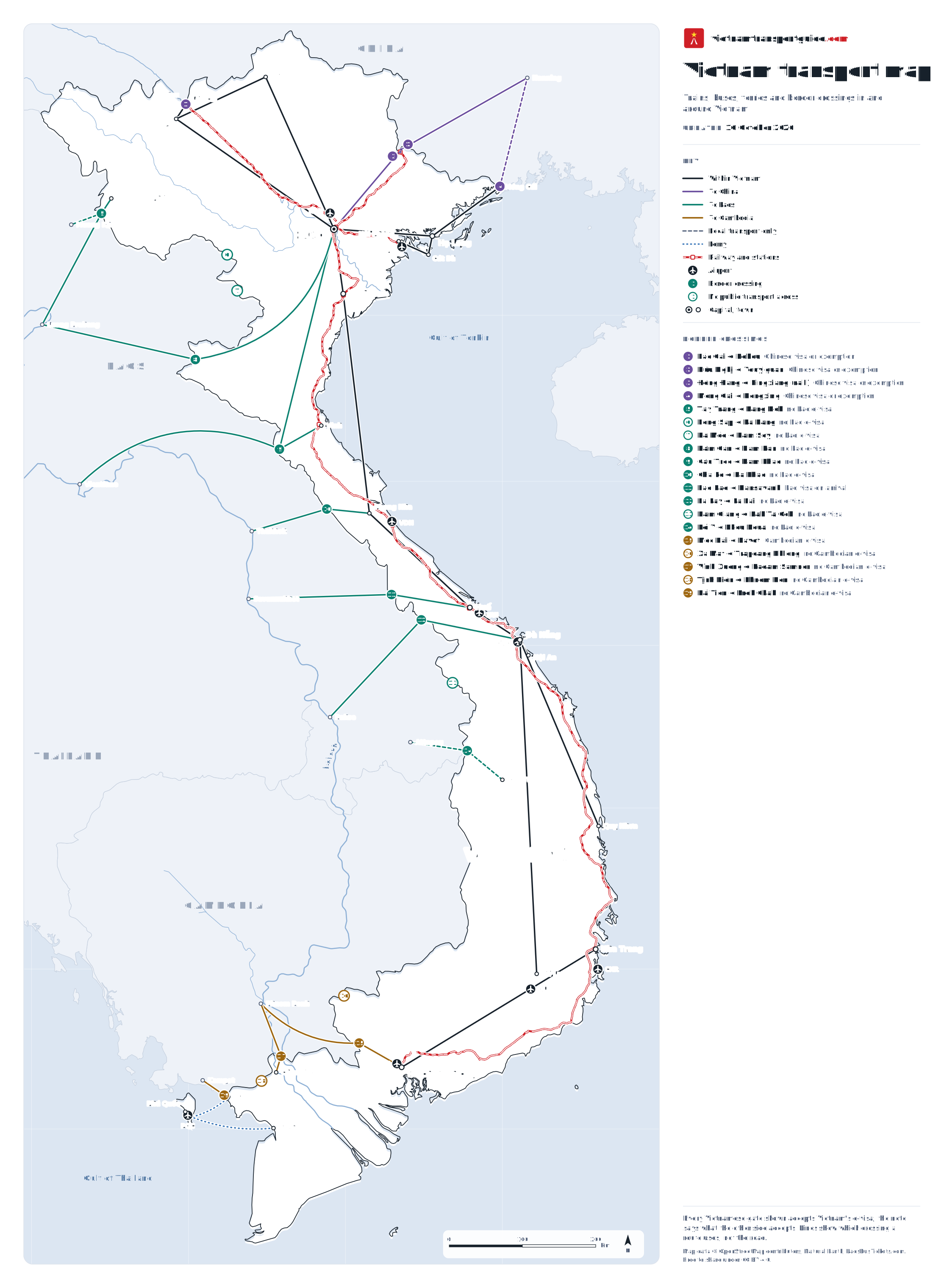
One map of the railway, the bus and ferry routes this site covers, nine airports and 19 border crossings with China, Laos and Cambodia. Every Vietnamese gate shown accepts Vietnam's e-visa, and each crossing is marked with what the other side accepts. Tap the map to open it full size; it is free to share.
What the map shows
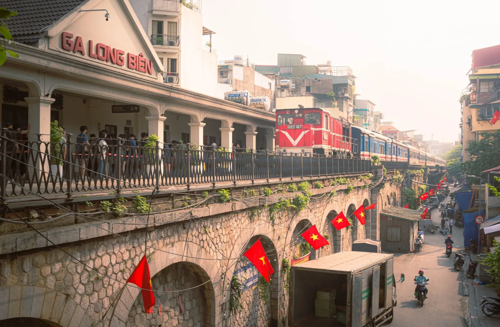
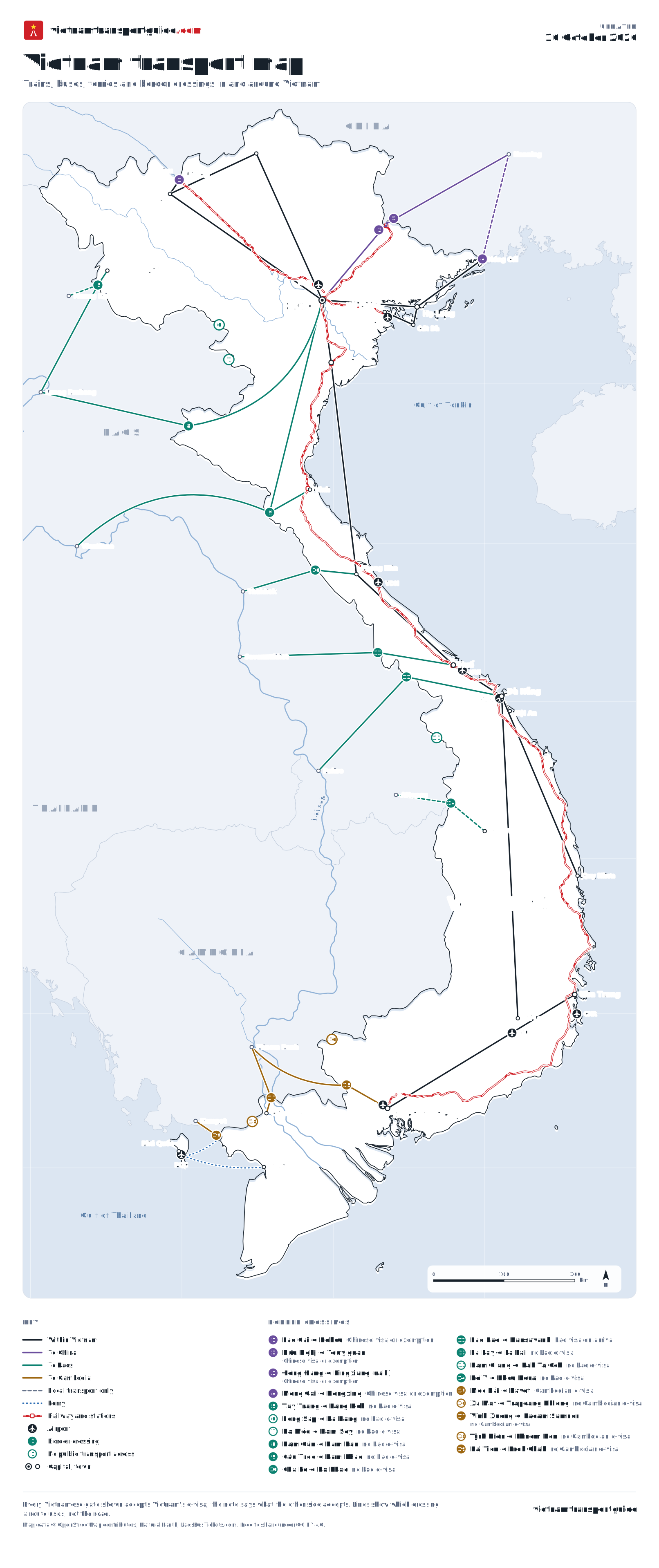
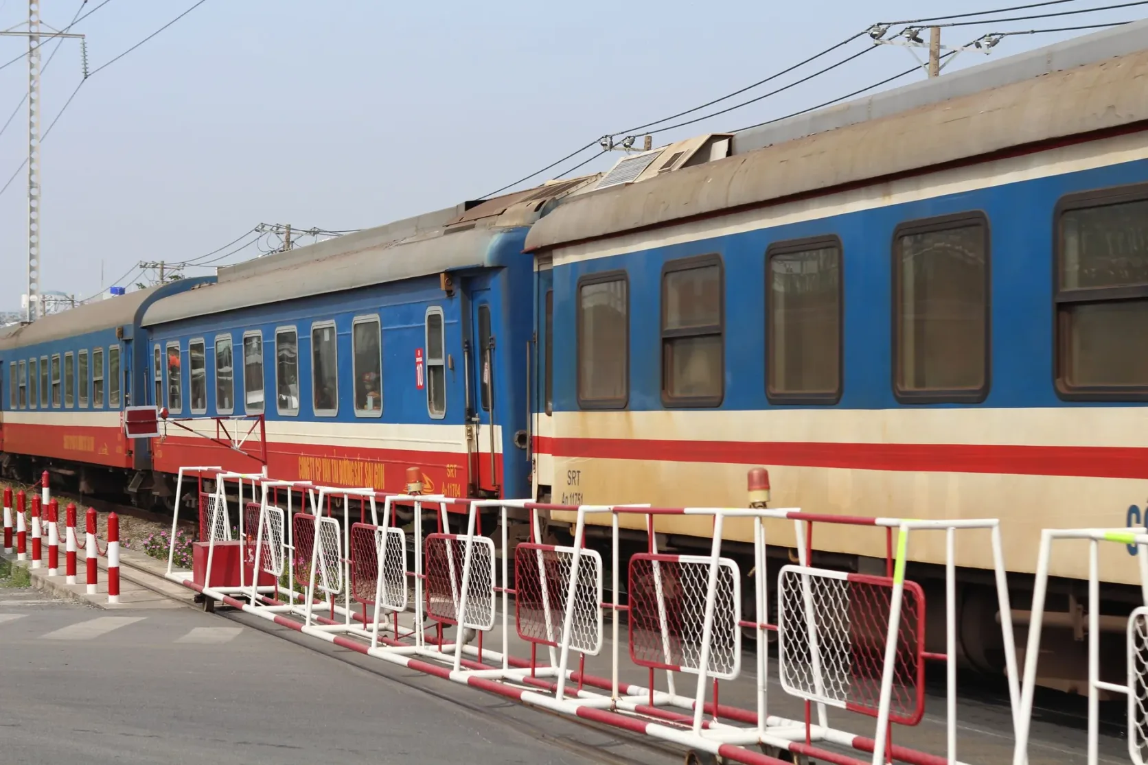
Railway. The red line is Vietnam Railways: the North–South line from Ga Hà Nội to Ga Sài Gòn through Ninh Bình, Vinh, Đồng Hới, Huế, Đà Nẵng and Nha Trang, and the branches to Lào Cai (for Sapa), Hải Phòng and Đồng Đăng, where the Gia Lâm–Nanning train crosses into China. The train guide has times and fares.
Road routes. Dark lines are the bus and van connections covered on this site: Hanoi to Sapa, Hà Giang, Hạ Long and Ninh Bình; Ninh Bình to Phong Nha and on to Huế; Huế, Đà Nẵng and Hội An; Đà Nẵng to Quy Nhơn and Đà Lạt; Ho Chi Minh City to Nha Trang.
Long journeys along the coast, such as Hanoi to Ho Chi Minh City, are not drawn end to end: the railway shows that corridor.
Across the borders. Purple runs to China, Hanoi to Nanning through Hữu Nghị; brown runs to Cambodia, Ho Chi Minh City to Phnom Penh through Mộc Bài, and Hà Tiên to Kampot. Dotted blue lines are the boats to Phú Quốc from Hà Tiên and Rạch Giá.
Into Laos. Teal runs to Laos: Hanoi and Vinh to Vientiane through Cầu Treo, Hanoi to Luang Prabang through Nậm Cắn, Điện Biên Phủ to Luang Prabang and Muang Khua through Tây Trang, Huế to Savannakhet through Lao Bảo, Đà Nẵng to Pakse through La Lay and to Thakhek through Cha Lo, and Kon Tum to Attapeu through Bờ Y.
Boats, footpaths and symbols. Hang Chau's boat links Châu Đốc and Phnom Penh through Vĩnh Xương; from Lào Cai you cross on foot to Hekou, and from Móng Cái to Dongxing for the trains to Nanning. Dashed lines are local transport only, bought on the spot; an outlined number marks a crossing with no public transport across.
Airports. The plane symbols are the nine airports this site covers, with their codes, from Nội Bài (HAN) to Tân Sơn Nhất (SGN) and Phú Quốc (PQC).
Border crossings on the map
| Crossing | Other side | Checked | Guide |
|---|---|---|---|
| 1 Lào Cai ↔ Hekou | Chinese visa or exemption | 16 October 2026 | Vietnam–China border |
| 2 Hữu Nghị ↔ Youyiguan | Chinese visa or exemption | 16 October 2026 | Vietnam–China border |
| 3 Đồng Đăng ↔ Pingxiang (rail) | Chinese visa or exemption | 16 October 2026 | Vietnam–China border |
| 4 Móng Cái ↔ Dongxing | Chinese visa or exemption | 16 October 2026 | Vietnam–China border |
| 5 Tây Trang ↔ Pang Hok | no Lao e-visa | 16 October 2026 | Vietnam–Laos border |
| 6 Lóng Sập ↔ Pa Hang | no Lao e-visa | 16 October 2026 | Vietnam–Laos border |
| 7 Na Mèo ↔ Nam Soy | no Lao e-visa | 16 October 2026 | Vietnam–Laos border |
| 8 Nậm Cắn ↔ Nam Kan | no Lao e-visa | 16 October 2026 | Vietnam–Laos border |
| 9 Cầu Treo ↔ Nam Phao | no Lao e-visa | 16 October 2026 | Vietnam–Laos border |
| 10 Cha Lo ↔ Na Phao | no Lao e-visa | 16 October 2026 | Vietnam–Laos border |
| 11 Lao Bảo ↔ Dansavanh | Lao visa on arrival | 16 October 2026 | Vietnam–Laos border |
| 12 La Lay ↔ La Lai | no Lao e-visa | 16 October 2026 | Vietnam–Laos border |
| 13 Nam Giang ↔ Dak Ta Ock | no Lao e-visa | 16 October 2026 | Vietnam–Laos border |
| 14 Bờ Y ↔ Phou Keua | no Lao e-visa | 16 October 2026 | Vietnam–Laos border |
| 15 Mộc Bài ↔ Bavet | Cambodian e-visa | 16 October 2026 | Vietnam–Cambodia border |
| 16 Xa Mát ↔ Trapeang Phlong | no Cambodian e-visa | 16 October 2026 | Vietnam–Cambodia border |
| 17 Vĩnh Xương ↔ Kaoam Samnor | no Cambodian e-visa | 16 October 2026 | Vietnam–Cambodia border |
| 18 Tịnh Biên ↔ Phnom Den | no Cambodian e-visa | 16 October 2026 | Vietnam–Cambodia border |
| 19 Hà Tiên ↔ Prek Chak | no Cambodian e-visa | 16 October 2026 | Vietnam–Cambodia border |
Every gate in the table is on Vietnam's e-visa list, which Resolution 389/NQ-CP of 2 December 2025 brought to 83 gates, so the e-visa covers your entry into Vietnam at all of them. What decides most trips is the other side:
- China. The 240-hour visa-free transit does not apply at any crossing from Vietnam: you need a Chinese visa or a passport that qualifies for the 30-day exemption. See the Vietnam–China border guide.
- Laos. None of these gates is on the Lao e-visa portal's list of entry ports, and Laos's register shows a visa on arrival only at Dansavanh, opposite Lao Bảo. The lines into Laos follow the crossing each bus uses on LaosBusTickets' checked routes; the Vietnam–Laos border guide has the buses, and LaosBusTickets' Laos transport map shows the Lao side.
- Cambodia. Bavet, opposite Mộc Bài, is the only crossing from Vietnam that takes Cambodia's e-visa. See the Vietnam–Cambodia border guide.
For Vietnam's own visa rules, exemptions and the e-visa itself, see the Vietnam visa guide.
Using and sharing the map
The lines show which crossing a route uses, not the road, so use the map to plan the order of a trip and the route pages for times and fares. Tap the map to open it full size; on a phone you can then pinch to zoom.
The map is free to share and embed under a Creative Commons Attribution 4.0 licence; please credit VietnamTransportGuide.com and link to this page.
Download the data
The crossings and lines on the map are available as data, for anyone who wants to reuse or check them:
- Border crossings as JSON and as CSV: position, what the other side accepts, check date and sources for each crossing.
- The whole map as GeoJSON: crossings, airports, piers, stations, towns, connections and the railway.
- The map itself, in portrait and landscape.
Positions come from OpenStreetMap, so the data files are under the Open Database License: credit "© OpenStreetMap contributors" and VietnamTransportGuide.com.
How this map is made and kept current
- Places. Each town is its OpenStreetMap place, or after Vietnam's 2025 ward mergers its ward centroid, checked against Wikidata. Stations, airports, piers and border posts are OpenStreetMap objects; the Laos gates use the positions LaosBusTickets verified, and every border post was viewed on satellite imagery. Borders, coast and rivers are from Natural Earth.
- Lines. A line is drawn only for a connection that a page on this site states. The map is regenerated from the same data whenever the site is updated, and the weekly check re-reads the border and visa sources.
- Changes. 16 October 2026: map published, with 19 crossings, 9 airports, 4 railway lines and 20 connections. Later the same day: lines into Laos, the Châu Đốc–Phnom Penh boat, Lào Cai–Hekou and Móng Cái–Nanning added, and the five crossings with no public transport across marked (33 connections in all).
Sources
- Báo Điện tử Chính phủ (Government of Vietnam news portal)
- Vietnam e-visa portal (Immigration Department, Ministry of Public Security)
- Vietnam National Railway Group (Tập đoàn Đường sắt Quốc gia Việt Nam, VNR)
- National Immigration Administration of China
- Lao PDR Department of Immigration
- Kingdom of Cambodia e-Visa (official government website)